Mt. Rinjani Hike 3D2N Travelogue.

22/7/2022
4 am, I woke up to half-packed luggage. I took the last-minute pack up a notch with just-in-time laundry. It’s been a decade since I stepped foot in Indonesia; it was in Jakarta. Now I’m going to the west, to an island near Bali called Lombok. It’s not as famous as Bali in the public eye. I’m not here to unwind and relax by the beach with sunglasses, drinking mocktails but to do the opposite. To make an attempt to climb Mt. Rinjani.


I’ve climbed Mt. Nuang and Mt. Rajah; both have similar topography and terrain and took less than a day to complete the course. What is different with Mt. Rinjani is that it has a dormant volcano; the last eruption was recorded on 14:45, 27 September 2016.

We reached the KLIA2 airport around 6 am. Right before morning prayers, we checked in our bags. For those travelers who plan to visit Indonesia, it’s mandatory to install PeduliLindungi apps, a Covid19 tracking app from the Ministry of Health Indonesia.
Three hours after the departure, we made it to Lombok for the first time. We had Tilawang chicken for lunch and made our way to Sembalun.


We stopped by Eiger, an Indonesian brand outdoor equipment shop. The design and quality of their products are excellent, on par with international brands like Solomon, Hi-Tec, and North Face.


It took us a couple of hours to reach Pusuk Sembalu. It was around 6 pm. We stopped by Taman Wisata Pusuk Sembalun, where we started to feel the coldness of the mountain climate. Local people were selling hot coffee for the visitors, around 5000 rupiah per cup. It was a delightful experience sipping hot drinks in cold weather.
It’s been 12 hours+ since we made a move from Malaysia to where we are now. By the time we reached the homestay, its already dark, around 7.30 pm. There was a small restaurant near our homestay. I had Indonesia's national dish, Nasi Goreng, and cap-cay (Hokkien-derived term for a popular Chinese Indonesian and Peranakan stir-fried vegetable dish that originates from Fujian cuisine - thanks wikipedia). It was pretty good.
We packed our bags for the big day tomorrow. We tried to keep our bags as light as possible. Other heavy items and clothes were left and transferred to Torean by our local guide (Torean is the place where we will come down from the hike on the third day).


5.30 am. When we reached the homestay, it was pitch black. We have no idea what was in front of our homestay when the sun started to rise at 6.10 am; lo and behold! We can see the peak of Rinjani from here. There are another two mountains alongside, and the sunrise was stunning. The diffraction of light on the mountain and the skies changes every time we look up.


One thing that is hard about Mt. Rinjani is the sandy terrain. It’s not sand like you see on the beach. It’s more like fine ash. I assumed it was formed from the volcano eruption. Every time you try to take one step forward, your feet will sink into the sand and bring you back down. There was a time I felt like I was static, not moving anywhere, but we kept on clinging to the rock to keep our momentum forward. One of the tips from Dian, try to follow the footsteps of the people in front of you to minimize your foot sinking into the sand (I tried, did not work. Lol)


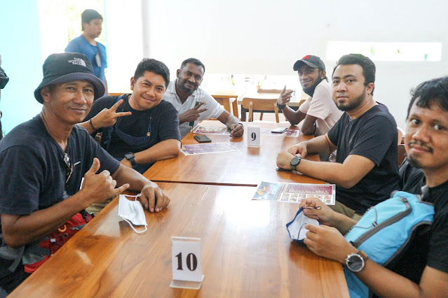
At 9 am, everyone was hype and ecstatic to start the hike. After the big breakfast, we received aid from the pickup truck to get us to the foothill, and the “suffering” began. It was an accessible route. At first, it was up and down terrain, and the cold wind accompanied us along the way. Fluffy clouds drifted across the clear, blue sky that made us feel re-energized every time we stopped to catch our breath. It was around 7 hours of a hike from the foothill to the campsite.


Even if you are a local or tourist from the east or west, we have a supportive attitude towards each other; a few sections of the terrain were tough. Sometimes we need support from the top, sides or a little push from below to keep moving. It’s like a big group of teamwork to get to the campsite.


“Oh fu*ked! f*cking hell”, I heard a scream behind me. A lady slipped after an attempt to take a big step across a gap. Just seconds later, she takes the words back, “sorry people,” haha. “Do you need a hand?”, “Oh, thank you so much, dear,” she replied.


5:45 PM, finally I reached the campsite. It feels like I’m already at the peak of Mt. Rinjani, seeing the clouds and sun start to set. I have no idea where my group was. Nowhere to be found. I kept walking alongside the campsite to find my group, and there they were, sitting at the end of the campsite, which is much close to the peak; it’s starting to feel really cold, the temperature here can drop to 1 °C or even lower at night. We had dinner with hot tea. At this moment, anything warm that you can chug in feels like a big blessing to keep the core body temperature up.
We got to relax our muscles while admiring the sparkling and shimmering light from the stars with all its glory. We went to sleep early to prepare ourselves physically and mentally to climb the summit at 3 am.

24/7/2022 - Summit Attack!
We could not sleep well in the tent. The low temperature kept waking us up. A Puffer jacket with a windproof jacket, plus a sleeping bag, were just insufficient to be a barrier from the extreme climate.
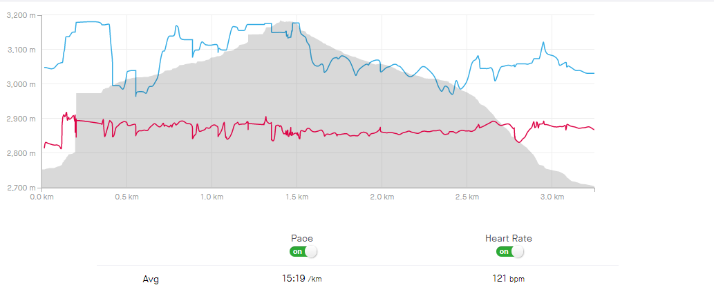
3 am, everyone getting ready to start hiking again. The terrain would not be that hard if it wasn't for the low temperature and the sandy surface; for every 10 meters hike, I would need to stop and catch my breath, as you can see on the map below the distance from the campsite to the peak is only 3km++, (map below it's actually a returned distance back to the campsite). I stopped at around 3200m. The height of Rinjani is 3726m, just shy of 500m. I could not go further because I was too exhausted from yesterday's hike and improper sleep.


Around 7.30am. So much relief seeing the sun is up. The temperature around the campsite started to heat up. As we went down the mountain, it was smooth sailing. It's like skiing on the sand.


Reached the campsite around 9am. I just wanted to lie down and take a nap. My circadian rhythm was haywire at this time. We had lunch and rest because there would be another crazy adventure next, to get to the Segara Anak Lake (Lake near the volcano).

12pm, set off to the lake. This was the toughest terrain on this trip; 80% of the ground was solid rock. In Malaysia, we are used to the soil ground while hiking, even if we fall. The soil ground is not hurt that much. Our guide told us that a couple from Australia were severely injured from this terrain; the wife got a broken back, and the husband also got injured while trying to save his partner. And it happened in front of him; the couple was flown to the hospital by helicopter.


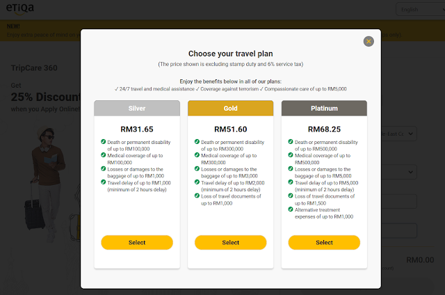
I bought travel insurance, but I don't think the coverage would cover Mt. Rinjani. After I came back to Malaysia, I did some checking. Most insurance companies only cover up to the mountain that is 3000m in height. Now, what if we get injured at the height of 500m At the beginning of the hike, would the insurance company allow us to claim the medical cost? Something you can ask your insurance provider during your next travel. I bought Zurich Travel Insurance because it’s the cheapest on this list I’ve checked.
In terms of the coverage, among Zurich, Etiqa and Allianz all three have the condition whereby it only covers mountaineering activity that is 3000m in height, for Allianz at 3500m. However Mt. Rinjani is 3726m. Maybe there’s a specific add-on you could do; I'm writing this blog after my travel ends, so if you know insurance that covers 3500m mountaineering activities and above. Let me know in the comment section.

Anyway, our guide told us that the couple from Australia paid lots of money to fly them to the hospital. I don't know if their insurance covers it or if it's something that is provided by the Indonesian authority for severe cases.
Enough said, right after hearing that story. I just lowered my pace and took my time going down the mountain. I keep imagining if I stepped onto loose rocks and lost my balance, this may be the last hike.
At last, after 6 hours of going down the mountain, we made it to the lake. There's a hot spring nearby the lake. The feeling when stepping into the hot springs was terrific! Surrounded by green mountains, it's definitely one of the things I would never forget.


Awake, super early again for the third time. It's time to go back to the city. The route we took was just established right after the COVID-19 breakout. Not many people have used it, and the view was another piece of the fantastic view of Rinjani. This time it's 11 hours of hike. It was tiring, but the terrain was accessible. It's soil terrain that is less risky, and we could get by it quickly.


Reached Torean!


27/7/2022
We got to our second homestay at Torean. This homestay is slightly better than the first day.
Nasi goreng for breakfast was good. I ordered extra eggs. In Malaysia we call it telur mata kerbau, but here they call it telur mata sapi. When the waiter asks telur mata sapi? Yes! That's the one, cause I know Sapi means cow. So IYKYK.
There are many similarities between Malay and Indonesian, even if the sentence I'm reading is the first time for me, with known grammar rules with the given context. Most Malaysian can take a good guess.


So to save some cost, we booked a big room with 5 beds and ordered another extra bed for our supir. We got you covered mas!
I really like this place called Sasaku, you can get almost every souvenir you can think of.

27/7/2022
It's time to go back, sayonara Lombok. It was a unique experience hiking in Indonesia. I would do it again in another country.
So the overall cost of the trip; around RM2900
RM995 - Tour Cost
RM850 - Return Flight
RM1000 - Pocket money


Comments
Post a Comment